How could a Global Disaster Database transform disaster resilience?
A new Global Disaster Database is hoping to use data from satellite imagery, geographic information systems and risk maps with existing information of disaster loss and damage to reduce the impacts of disasters.
The United Nations Development Programme (UNDP) is working closely with governments and research partners to collect data and create a database of disaster information. Once created the Global Disaster Database will be housed at the Global Centre for Disaster Statistics in Japan.
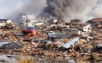
It is hoped that the data will be able to increase disaster resilience in Asia, a region particularly vulnerable to natural disasters. Since 1970 a person in the Asia-Pacific region has been five times more likely to be affected by a natural disaster than anyone outside of the region.
Similarly, between 1970 and 2016 Asia-Pacific lost $1.3 trillion in assets due to floods, storms, droughts and earthquakes.
A key aspect of the 2030 Agenda for Sustainable Development is disaster resilience, to date the UNDP has assisted 16 countries in the region to establish their own databases for disaster loss and damage. The databases are able to establish where disasters occur, what could happen on a yearly basis and guide budget decisions.
In some cases the databases contain decades worth of data which governments use to anticipate disasters and inform disaster resilience policies.
Sanny Jegillos, Disaster Risk Reduction Team Leader, for UNDP in Asia-Pacific noted:
“The challenge is that these are databases that are not linked with many other applications..the global database is about helping governments develop the capacity to incorporate other structured and unstructured data.”
Japan’s Tohoku University is currently researching tsunamis for the database, investigating how wave heights effect the number of fatalities. It is hoped that this will inform decisions on evacuation plans and protective infrastructure.
The UNDP is also looking into disaster and climate displacement in the Philippines and Indonesia in collaboration with Stockholm Environment Institute and the Internal Displacement Monitoring Centre. By combining all of the available data countries will be able to analyse where displacement happens, how many people are displaced, where they go and how long for.
Sanny Jegillos noted how the information will help reduce future displacement across the region and will allow countries to better assess root causes of displacement:
“One of the things that I’m seeing now is, in fact, many of these displacements do not just happen after the immediate impact of a flood or a cyclone, some of the displacements are actually more than one year later”
The data base will also provide stronger monitoring for the 38 Sendai Framework for Disaster Risk Reduction indicators and help governments create smarter disaster risk reduction plans.
Join us for the 10th Anniversary AIDF Global Summit in Washington D.C, USA on 5-6 September 2018 to discuss global disaster resilience.
If you’d like to stay informed on the latest updates in aid and development, please sign up for the AIDF newsletter.
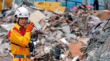
Image credit: REUTERS/Tyrone Siu
Recommended
-

-

AIDF are pleased to open nominations for the Africa Innovator of the Year Award 2019!
-

Just three countries support over 50% of the World’s refugees
-

-

-

UN report warns Asia-Pacific is falling behind Zero Hunger targets, as millions remain malnourished
-

WHO’s ‘World Malaria Report’ warns that global progress in eliminating the disease is stalling
-

Approximately 821 million people in 2017 suffered from hunger, according to new report
-

Every country in the world is falling short of malnutrition targets, warns new report
Subscribe To Our Newsletter
SubscribeRelated Articles
-
Mali set to improve its climate and hazard early warning systems
-
Developing Countries are in need of Recovery not just Resilience
-

6 months on, how is the Caribbean recovering from hurricanes and Irma and Maria?
-

Extreme weather is adversely impacting poor farmers, says FAO
-
Belgium boost funding for WFP’s latest blockchain and drone innovations
-

WHO increases its efforts to reach malnourished children in South Sudan